6.1 Case Study: Wicklow Mountains
In Chapter One, we talked about the Iapetus Suture, where two continents collided into one. Many of the mountains that cover Ireland’s landscape today developed during this moment in time, and the Wicklow Mountains are no exception.
In Wicklow, large areas of molten rock pushed upwards into mudstone and sandstone rocks; the subsequent Ice Age saw glaciation that resulted in U-shaped valleys indicative of the Wicklow Mountains, as well as rounded mountain peaks, corrie lakes, and boulder clay (Biodiversity of Wicklow County 2008). Much of the Wicklow mountains are covered in a blanket of peat, or a blanket bog (Biodiversity of Wicklow County 2008). In the below map (Figure 6.2), observe the diversity of the landscape in the Wicklow Mountains, the shows corrie lakes, forested areas and bogland, as well as the elevation of various peaks in the Wicklow Mountains (shaded in orange):

The Wicklow Mountains are located south of Dublin city on the eastern side of the island of Ireland. The River Liffey, that we learned about in Chapter 3, flows from the Wicklow Mountains, and thus the Wicklow mountains feeds both the River Liffey but also its connecting man-made waterways such as the Grand Canal discussed in Chapter Five.
Economically, the Wicklow Mountains are one of Ireland’s most visited tourist sites, in part due to its beauty and history, but also due to its proximity to Dublin city, where the majority of tourists arrive into the country. Tourists who arrive in Wicklow are afforded a range of opportunities, including tours of historic sites such as Glendalough (discussed below) but also leisure activities such as cycling, walking, hiking, and visiting historical sites independently.
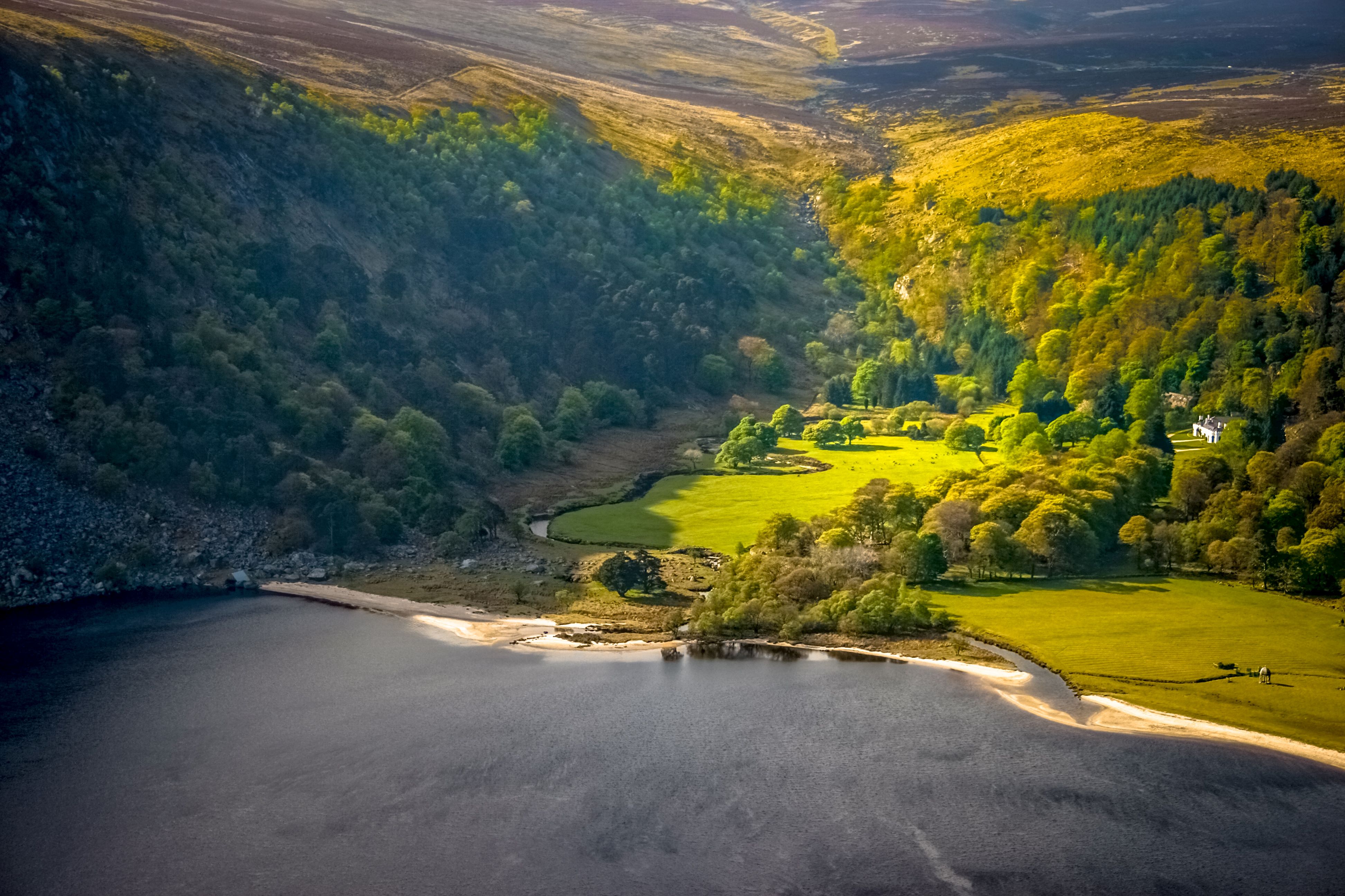
Glendalough
Glendalough is a U-shaped valley that formed during the last Ice Age. The Wicklow Mountains – that emerged during the forming of Ireland – experienced a build-up of ice and snow culminating in glaciers; as these glaciers melted, their weight crushed the rocks beneath them, creating cracks that led to erosion through the processes of plucking and abrasion. Plucking is a process of erosion, where meltwater enters cracks in the bedrock, is frozen, and the rock is then torn (or plucked) following the movement of the glacier. Abrasion is erosion through which a glacier’s load of rocks scrape and wear away the floor and sides of a valley (Dastrup 2020).
As the erosion took place over time, it formed widening valleys in V and U shapes, and this is the case for Glendalough, which appears U-shaped with steep cliffs on either side that flow into a flattened floor.
Glendalough Monastic Site
Glendalough, which means “Valley of the Two Lakes”, is not only an important landscape, but is also home to an important historical and religious site too. Glendalough’s monastic site, located just to the west of the village of Laragh, is an example of an early medieval ecclesiastical landscape. This means that the site is not only one building but rather a series of sites that link to Saint Kevin, a religious figure with origins in the area from the 6th century. In fact, it is known as a ‘Monastic City’, and includes a round tower, medieval stone churches, and decorated crosses, as well as a small-man-made cave in a cliff where St Kevin is said to have lived and prayed. During the 6th century, Glendalough was famous across Europe as a sought-after religious centre (Glendalough Monastic Site and Visitor Centre, Heritage Ireland. n.d.).
Interactive Video: Glendalough Monastic Site
Figure 6.4 Glendalough: Power, Prayer and Pilgrimage. © National Museum of Ireland, available on Youtube; included on the basis of the Standard Youtube License.
During the 6th century, Saint Kevin lived in the Wicklow mountains as a hermit, but soon gathered followers and subsequently established a monastery there. This became an important pilgrimage site at the time, and many visited because they believed the area to be holy. Due to its popularity it was also a site of invasion, including raids from Vikings and being burned by the English in 1398 (Monastic Ireland 2014). Despite these attempts, many of the original buildings from the “Monastic City” remain today and are an important part of the material history of Ireland.
Mining in Glendalough
As we learned above, Glendalough formed millions of years ago as a result of Iapetus Suture in Ireland. The coming together of these two continents in Wicklow created a large granite mass. As the granite cooled, cracks formed that were filled with hot fluids that created different types of minerals including lead, zinc, and silver (Our Wicklow Heritage 2020a).
In the late eighteenth century and into the early nineteenth century, mining commenced in Glendalough and surrounding areas to extract these minerals. Interestingly, the mining process led to an important physical change in the landscape: during the mid-nineteenth century, the Mining Company of Ireland planted around one million trees in Glandalough, as timber was needed to prop up mines but also because timber could be sold for profit (Critchley 2020). However, many of these trees were left untouched, as the mining industry in Wicklow ceased in the early twentieth century. In other words, the era of mining in Glendalough turned these mountains into the tree-lined Wicklow mountains landscape that it is known for today. These trees support Wicklow’s rich biodiversity, including noteworthy birds such as Goodsanders and Merlins (National Parks Wicklow Nature Conservation n.d).
Wicklow’s historical past
What can a road reveal about political geographies? Military road in county Wicklow may look like a transportation infrastructure for tourist cars and buses today, connecting Dublin visitors to the Wicklow Mountains for a day. A closer look reveals the intersections of physical, human, and cultural geography we have sought to explore in this text.
In Chapter Two, we discussed the long history of British colonial rule in Ireland and its impacts on the physical makeup of the landscape, in particular the ways that county lines were drawn on the map. Here, we can see how Irish resistance to colonial rule drew on knowledge of the physical landscape, but also how British colonial rule implemented physical changes to the landscape to enact control in new ways.
The Irish Rebellion of 1798 had an impact on the landscape of Wicklow, where an uprising of United Irishmen aimed to cut ties with Britain and attempted to overthrow British strongholds in Dublin. When they were unsuccessful, they lived in the mountains of Wicklow as this area had no navigable road and was unfamiliar to the British; in other words, the United Irishmen used their knowledge of the landscape including its peaks and valleys to hide and plan attacks on British forces. Following the rebellion, between 1801 and 1809, the British built a ‘military road’ in Wicklow so that it would be more easily navigable in the event of future conflict. Today it is a popular road for tourists to travel to see the Wicklow mountains (Our Wicklow Heritage 2020b)
Wicklow’s present
Today, farmers work on the hills of Wicklow mountains, farming sheep and goats who live on and graze the pastures of this terrain; thus, Wicklow mountains play an important role in farming as well, with cool temperatures and high elevation allowing for grasses to grow for livestock as well as providing water and shelter for animals too. Climate change, including resulting fires on the mountains, is having an impact on these farming practices and the habitats of sheep, goats, and other creatures who inhabit this space.
